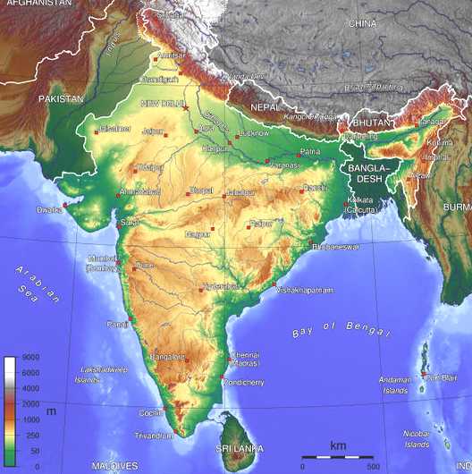
India the seventh largest country in the world, is well marked from the rest of Asia by mountains and sea, which gives the country a distinct geographical entity.It covers anarea of 32,87,2631 sq.km . Wholly in the northern hemisphere the mainland extends3214 km from north to south between the extreme latitudes and about 2933 km from east to west between extreme longitudes.It has a land frontier of about 15,200 km.
The country lies between 8 º 4 'and 37 ° 6' north of the equator and the Bay of Bengal in the east of the Arabian Sea in the west and the Indian Ocean to the south.The totallength of the coastline of the continent, surrounded Lakshwadeep group of islands andAndaman and Nicobar group of islands is 7,516.5 km. In the east the Northwest Bangladesh.In Afganisthan and Pakistan border India.The Gulfof Mannar and Wages Straits separate India from Sri Lanka. The Andaman and Nicobar islands in the Bay of Bengal and Lakshwadeep in the Arabian sea is part ofthe territory of India.There are as many as 200 islands in the Andaman alone, whichstretch for 19 350km.There Nicobar island group. The Arabian Sea consists of the Lakshadweep group. It is a coral deposits from theKerala coast, formed the southern most of these are just to the north of the Maldivesisland is an independent territory. The Indian sub-continent is characterized by a great diversity in its physicalcharacteristics. It can be divided into the following physical units:
Physical Features :
Himalayan MountainThe Himalayan mountains and the associated arcs gridling the sub-continent in the field in a steady north-south-easterly direction for about 2400 km between the rivers of the industry and the Tsango Bhramaputra.The section between the Indus and the Sutlej and Kali Kumaon Himalayas as described. The other two sections between the Kali and Tista and between the latter river and the Dihangare described as Nepal and Assam Himalayas.Kanchanjunga (8598 m) is the highest mountain peak in India.The Greater Himalayas, which is an average elevation of 6000 m within them almost all the prominent peaks such as Everest (8848m), Kanchenjunga (8598m) Nanga Parbat (8126m), Nanda Devi (7817m) and Namcha parbat (7756m).The Indus-Ganga-Brahmaputra PlainThe great plains of India formed by the Indus, Ganga and Brahmaputra rivers. the plain stretching 3200 km between the mouth of the Ganga and the industry, along the foot of the mountain ridge with a width ranging from 150 to 300 km. The longitudinal profile bars of the banks of the Ravi and Sutlej the the Ganga delta of only 2400km. The plain is narrowest in Assam and extended westward. It is 160 km wide near the Rajmahal Hills and 280 miles near Allahabad. The plains are alluvial in nature.Peninsular plateauRising from the alluvial plains of Uttar Pradesh and Bihar, south of the Yamuna Ganga line, the great Indian plateau stretching to the south to the entire peninsula to include.With a height of 600-900m, the plateau makes an irregular tringale with its concave base between Delhi Ridge and Rajmahal hills, formed by the Apex Kanya Kumari. The remote projection of the plateau of the peninsula by the Aravallis, Rajmahal Hills and Shillong contribute an idea of the original northern boundary.The location of another fragment of the peninsula block in the Shillong plateau gives an indication of the possible connection. The Shillong Plateau is a highly dissected and jungly channel drops into a deep slope in the direction of the surma valley.The northern outliers are represented by the Rengma Mikir hills.Western GhatsThe topography of the Deccan and the Karnataka Plateau, is dominated by the Western Ghats, which stretches unbroken to the southern tip of Peninsula.They an overall height of 900-1100 m, sometimes up to 1600 m or even more.Near Goa highly dissected relief of the lava rocks are replaced by smooth, rounded hills of granite and Gnesis.In this section of the Ghats dip, but rises again in the Nilgiris.Further south of the continuity of the Ghats are spread through the Palghat gap and Shencottah gap.The Cardamom Hills, can be regarded as the continuation of the Western Ghats.Eastern GhatsThe Eastern Ghats are generally less impressive than theWestern Ghats form a discontinous crest on the eastern peripheryof plateau.They repesented by an irregular line of hills, as Nallamalais, Velikondas, Palkondas and Pachaimalais. These hills are often referred to as the North Hills in the northern sector, Cuddapah exchange in the middle and the Tamil Nadu Hills in the south.The coastal plains and islandsThe plateau is surrounded by coastal plains of varid width ranging from Kutch to Orissa.There is a striking difference between the eastern and western coastal plains, with a notable exception of Gujarat, the West Coast the narrow alluvial margin varied by hillty site This indentation, except in the south, where the beautiful lakes set an element ofdiversity ..The east coast on the other hand, a wide plain with a well developed deltas of large rivers. The climatic transition between the South-West monsoon regime of the north and north-east rainfall regime of the South led to interesting differences in the alluvial features in two different parts of the eastern coastal plain.
River System of India :
The rivers can be classified as follows:
- the Himalayas
- the Deccan
- Coastal
- The rivers of the interior drainage
The Himalayan rivers are generally snow-fed and flow throughout the course of the year.During the rainy months (June-September), the Himalayas receive very heavy rainfalland the rivers carry the maximum amount of water, causing frequent floods.
The Deccan Rivers
The Deccan rivers are generally rain-fed and therefore vary greatly in volume. A verylarge number of them are non-perennial.
The Coastal Rivers
The coastal rivers, especially on the West Coast, is short and has a limited catchment areas. Most of these are non-perennial as well. The rivers on the inland drainage basinare few and ephemeral.
The rivers of the inland drainage basin
They drain to individual basins or salt lakes like the Sambhar or are lost in the sand with no outlet to the sea.
Others Geographical Facts :
ClimateThe Himalayan range in the north acts as the perfect meteorological barrier for the whole country.Even though it falls under the category climatical Monsoon, the climate varies from place to place another.Also despite the country's size and the diverse relief, the seasonal rhythm of the rain is clear throughout.Some surrounding mountains in the north by China, Nepal and Bhutan.A of the mountain range stretching from India Burma.Although separate much of northern India lies beyond the tropical zone, thecountry has a tropical climate characterized by relatively high temperatures and dry winters.
The rainfall is very heavy in the north-eastern region, the western slopes of the Western Ghats and parts of the Himalayas, which has more than 2,000 mm annually. The eastern part of the peninsula, which extends to the northern plains, received rainfall ranging from 1000 to 2000 mm a year, while the area of the West - Deccan to the Punjab plains between 100 mm and 500 mm per year. Rajasthan, Kachchh and Ladakh hardly a rainfall.The population of India over the billion mark at the turn of the millennium.
Natural vegetationThe Himalayan region, rich in vegetative life, possesses varieties that practically from the tropical regions found tundra. Only the height affects the distribution of vegetation. In the rest of the country, mainly the type of vegetation determined by the amount of rainfall. Outside the Himalayan region, the country can be divided into three major vegetation zones: the tropical wet evergreen and semi-evergreen forest, tropical deciduous forests and thickets and shrubs.
Vegetation of the Assam region in the east with luxuriant evergreen forests, occasional thick clumps of bamboo and tall grass. The Gangetic plain is largely under cultivation.The Deccan plain supports scrub vegetation of mixed deciduous forests. The Malabar region is rich in forest vegetation. The Andaman and Nicobar Islands evergreen, mangrove, beach forest and diluvial. Many of the country's flora three million years ago and is unique to the sub-continent.
PopulationThe population of India over the billion mark by the turn of the millennium. The massive census of 2001 is in the process of being compiled. In 1996 the population was 945 million with 73% in rural areas. In terms of population, India is the world's second largest country after China. 16% of the world's population lives in India. The average population density is 320 per sq km (1996), although it is 6888 per sq km reached in the larger cities. In July 2003 it 1,049,700,118 (estimate)
LanguagesIndia, according to a recent census in 1652 dialects. Needless to say that most of them are only spoken dialects. The main languages with rich literary heritage: - Assamese, Bengali, English, Gujarati, Hindi, Kannada, Kashmiri, Malayalam, Marathi, Oriya, Punjabi, Sanskrit, Sindhi, Tamil, Telugu and Urdu.
Natural resourcesCoal (fourth largest reserves in the world), iron ore, manganese, mica, bauxite, titanium ore, chromite, natural gas, diamonds, petroleum, limestone, arable land
Environment current issuesDeforestation, soil erosion, overgrazing, desertification, air pollution from industrial effluents and vehicle emissions, water pollution from raw sewage and runoff of agricultural pesticides, tap water is not potable throughout the country, large and growing population is overstraining natural resources
India is a land of incredible diversity. The diversity of the Indian population is matched by the incredible physical diversity. The sixteen official languages of India, the five major religions and the caste system, a somewhat chaotic situation for the nation. It dominates South Asian subcontinent; near important Indian Ocean trade routes.
INDIA:
Based on climate change, the geographic regions of India the next big parts in:
Northern Plains
Known for extreme type of climate, the northern plains of India stretching from Assam in the east to Punjab in the west going to the Rann of Kutch in Gujarat. Also known as theGangetic plains, this region has some of the major Indian rivers winding through it likeGanges, Brahmaputra and the Yamuna. These plains experienced a relatively warm and humid in summer, followed by a freezing cold winter. These plains receiveabundant rainfall during July-September. But winter is still considered the best time of year in this region for the maximum number of tourists flock the area during that time.
Western Himalayas
The Himalayas is the second major climatic regions of India for most of theenvironmental changes in India owe their frequency and impact it has. Summer is thebest season to visit the region as the massive rainfall in the winter to make the placeimpossible to reach. This is due to the Himalayas only cold and extremely cold winterbreezes rising from the Western ocean can not reach the country.
Central India
This region of the country takes up heat during the summer season. Moon in Julyremains much awaited month in the region for a heavy rainfall through the rain. The winter months in the central parts of India contrasting climatic changes into account for the temperature is usually in the night drop.
West Indies
A very warm temperatures experienced in the western parts of India, and then the raincame as a relief in the months of June and September. The winter months are a littlelight on this part of the country with a temperate climate.